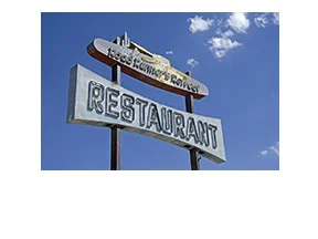
Rice, Cal

Rice, Cal

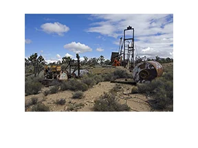
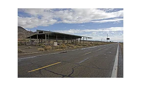
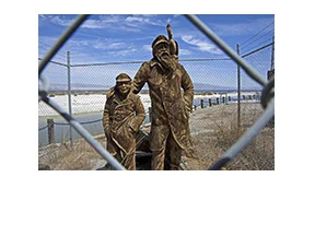
I’d just finished exploring Desert Center and was on my way to see what I could find in Rice. It would be a 50-mile drive, and would take about 30 minutes to get there, unless I saw something interesting along the way. I made it to Rice in 30 minutes. Not to say that there aren’t interesting things to see along U.S. Route 177 between Desert Center and Rice, besides huge expanses of Colorado Desert. There are several U.S. Army Desert Training Camps which were in full operation during WWII, but the sites are well off the highway and have been almost completely returned to native habitat. There are also a number of off-road tracks leading to who-knows-where. But those are things for another day. I was in the mood for Rice.

Read More

Desert Center, Cal

Desert Center, Cal

"Desert" Steve Ragsdale founded the community of Desert Center back in 1921. He had the large, adobe-style concrete Cafe, gasoline station and service garage built to entice travelers to stop in for food, gas and a shady spot to rest. Next to the cafe, he built a large "plunge," where travelers could escape the desert heat by taking a quick dip. A number of "cabins" on the west end of town provided a place to stay for folks who wanted to spend the night before continuing on their journey. A Post Office, general store, and other buildings opposite the Cafe were also built by Desert Steve and still stand today.

Read More

Tuttle Creek Rock Houses, Cal

Tuttle Creek Rock Houses, Cal

I was in the Lone Pine area and didn't have enough time to thoroughly explore the Alabama Hills (that is going to happen though), so I hiked to a couple arches and drove to a couple old rock houses. This is the story of the Rock House Expedition.

Read More

Death Valley Mine, Cal

Death Valley Mine, Cal

So the first thing to say about the Death Valley Mine is, it's not located in Death Valley.

A man by the name of J.L. Bright discovered the Death Valley Mine in 1906, why he chose that name is anyone's guess, as the location was some 70 miles from Death Valley.

With the prospect of gold or silver, it wasn't long before a mining camp known as Dawson sprung up nearby. Named after the directors of the Death Valley Milling and Mining Company of Denver (who had bought the property from Bright shortly after his discovery), the inhabitants of Dawson worked not only at the DVM, but at other mines in the area as well.

Read More

Yermo, Cal

Yermo, Cal

The name "Yermo" is derived from the Spanish word for "Wilderness." Which seems appropriate. Out in the Mojave Desert, with the Calico Mountains to the north, the area must have seemed quite desolate when it was first settled. The town was once known as "Otis," after Gen. Harrison Gray Otis, a wealthy land and mine owner in the area. The Postal Service changed the name to Yermo in 1905, possibly due to a rift between Otis and the local miners union, legend claims.

Read More

Salton Sea - Desert Shores

Salton Sea - Desert Shores

I drove through Desert Shores recently, mainly to take some pictures of what is left of a resort near the water's edge. I'm not sure yet if it was part of the Desert Shores Yacht Club, or maybe the Marina Mobile Estates, but the remains of whatever it was are still impressive. I'll bet it was something to see back in the day. The attraction of old, abandoned places seems to have a hold on me.

Read More

Salton Sea - Bombay Beach

Salton Sea - Bombay Beach

The Salton Sea is actually the largest lake in California. It was created by accident in 1905 when a cut in the bank of the Colorado River resulted in an overflow that overwhelmed the canal which was supposed to contain the runoff. The river basically flowed unchecked into the historic dry lake bed of the Salton Basin for two years before repairs were completed. Oooops. Things happen.

Read More

Rt 66 - Tucumcari, NM

Rt 66 - Tucumcari, NM

As soon as I drove into Tucumcari, it was plain to see that this town must have been one of the premier towns of old Route 66. There are traces of those glory days on each side of 66, all through town. From neon signs to old cafes and motels, it's definitely a photographer's dream. But I'm going to start this post with a spot I stopped at a little west of town, south of I-40 at Exit 321.

Read More

Rt 66 - Meteor City, AZ

Rt 66 - Meteor City, AZ

I was driving fast on I-40, just out of Two Guns, when I spotted the huge geodesic dome of the Meteor City Trading Post. At a quick glance, it looked like the place was still in business so I turned off Exit 239 to see if I could buy some souvenirs. I needed some Christmas presents. Unfortunately, when I got closer I could see that the Trading Post was no longer trading.

Read More

Rt 66 - Twin Arrows Trading Post, AZ

Rt 66 - Twin Arrows Trading Post, AZ

The iconic Twin Arrows once lured travelers to exit Route 66 and stop at the Twin Arrows Trading Post; for gas, food and various sundries. They lured me as well, and once I figured out how to get off I-40 and somewhat close to them, I was on a narrow piece of blacktop without much room to safely park. But I found a spot and hoofed it on over the check out the trading post ruins and examine the giant arrows, up close.

Read More

Rt 66 - Goffs, Cal

Rt 66 - Goffs, Cal

My first stop in Goffs was the 100-year-old Goffs Schoolhouse. It’s a one-room mission style desert school built in 1914 by the County of San Bernardino. It has been completely restored and returned to its 1914 feel and appearance. It’s been placed on the National Register of Historic place and is currently a museum and cultural center. The surrounding grounds are filled with interesting artifacts of years gone by. Unfortunately, it was closed when I arrived. Click HERE for more history on the old school and town.

Read More

Dunmovin, Cal

Dunmovin, Cal

If you've ever driven through the Mojave Desert on U.S. Route 395, chances are you've seen this abandoned stone restaurant and wondered about its history. All you catch of it is a glimpse when you're doing 85 mph on the highway. But it's interesting. It sticks in your mind. It beckons. You say to yourself, "self, one day I'm going to stop at this place and see what I can find."

Read More

Rt 66 - Lenwood, Cal

Rt 66 - Lenwood, Cal

I was driving along a short (36-mile-long) section of the National Old Trails Road, between Victorville and Barstow, Cal. Also known as the Ocean-to-Ocean Highway when it was established in 1912, the National Old Trails Road stretched some 3,096 miles from Maryland to California. When Route 66 was established years later, it incorporated much of the National Old Trails Road into its route.

Read More

Old Homestead

Old Homestead

This old homestead is located on Hwy 247 just a short distance north of Lucerne Valley. I had just tracked down the King Clone Creosote and was on my way to Barstow when I spotted someone taking pictures of several abandoned buildings on the opposite side of the road. This place called to me and I had to stop to take some pictures. Something draws me to these places and I often wonder what stories the old places could tell.

Read More

Route 58 Stone Ruins

Route 58 Stone Ruins

I was driving west on Route 58, out of Barstow, heading to I-395 and points north. My first stop of the day was going to be the abandoned Boron Air Force Station/Federal Prison Camp located a few miles north of Kramer Junction. As I'm speeding along, eating a cookie, I spot some old stone walls out in the middle of the desert. I passed by too quickly to be able to stop, so I continued up the road until I could turn around and go back to investigate. 

Read More