
Eagle Cliff Mine
/Having finished our reconnaissance of the Desert Queen Mine, obtaining a sufficient quantity of photos for our purposes, Murbachi and I set out for our second destination of the day. We were heading to the Eagle Cliff Mine, one of my favorite destinations in the park.
As with many of the mines in J Tree, few details are known about its origin, ownership and production over the years. The scant records so far discovered reveal that on May 27, 1895, a lead ledge that became known as the Eagle Cliff mine was located by Robert Muir. My hat's off to him. Back in the 1890s, it would have taken a true explorer to discover this claim. For the year ending December 31, 1897, some $200 worth of labor had been performed in the area, with two shafts being sunk into the rock; one to the depth of 75 feet, the other to 40 feet.
Bill Keys reportedly held possession of the mine for many years, at which time it was known as the Black Eagle. His son, Willis Keys, relates that his father kept up the assessment work from about 1916 onwards and during the 1920s and early 1930s, small amounts of ore were extracted from the mines which was processed at the Wall Street Mill. The main problem was getting the ore to the mill, as the location was extremely difficult to get to. In fact, the ore was packed out on a burro. Follow along and you'll see why.
There are at two routes that I know of that hikers can take to reach the Eagle Cliff. I've taken the route from Split Rock Boulder and the route from the Pine City backcountry board (the route taken for this report). I definitely recommend the route from the Pine City parking area over the trail from Split Rock Boulder. There's more interesting stuff to see, and it's not as strenuous.
After reaching Power Shopping rock at the summit of the Desert Queen Mine area, it was time to start heading east to pick up the wagon road/trail that would take us to the Eagle Cliff Mine. The road wasn't too hard to find, and for most of the next 3/4-mile or so, the trail was fairly easy to keep track of.
The image directly above shows the road cutting diagonally up and across the hillside. Once again I marveled at the work that went into creating these roads that often led to mines that never payed out.
Keep climbing and some nice vistas open up. This is looking southwesterly. That's Mt. San Jacinto, about forty miles distant.
Lots of bits of color were scattered all about as we continued along the trail. That's one of the nice things about hiking in the Spring, especially after a good rainy season in the park.
The Nolinas didn't want to be outdone by their prickly neighbors, so they were putting on a good show of their own.
Getting close. This portion of the trail is a bit of a scramble. The trail never really disappears, but it does zig-zap up this rocky slope. It doesn't really matter which way you go, as long as you reach the summit of the saddle on the left.
Spotting a pile of tailings that I remembered from a previous trip, I knew we were on the right track. This tunnel goes directly into solid rock.
Maybe about twenty feet or so in, before it dead-ends.
I always like taking of picture from inside, looking out towards freedom and safety.
Looking back down the zig-zag, that's Queen Mountain off in the distance. I've read that there is some spectacular scenery up there and in the canyons around it, but it's rather remote and takes some good planning and some serious hiking to get to it. Maybe someday....
From this point, there is a faint trail that leads off to the northeast, and one that continues southeast up and over the saddle. The northeast trail is the direct route, but going up and over the next ridge is also an option, as once that's done, the path swings north and soon meets the other trail.
And here we are. The pile of tailings in the foreground came from one of the main tunnels of the Eagle Cliff Mine. It's opening is just to the right of the pile, nearly covered by a spreading oak tree.
It's a bit of a scramble down to go look into the tunnel, and as it's most likely gated, this is as close as I got to this one.
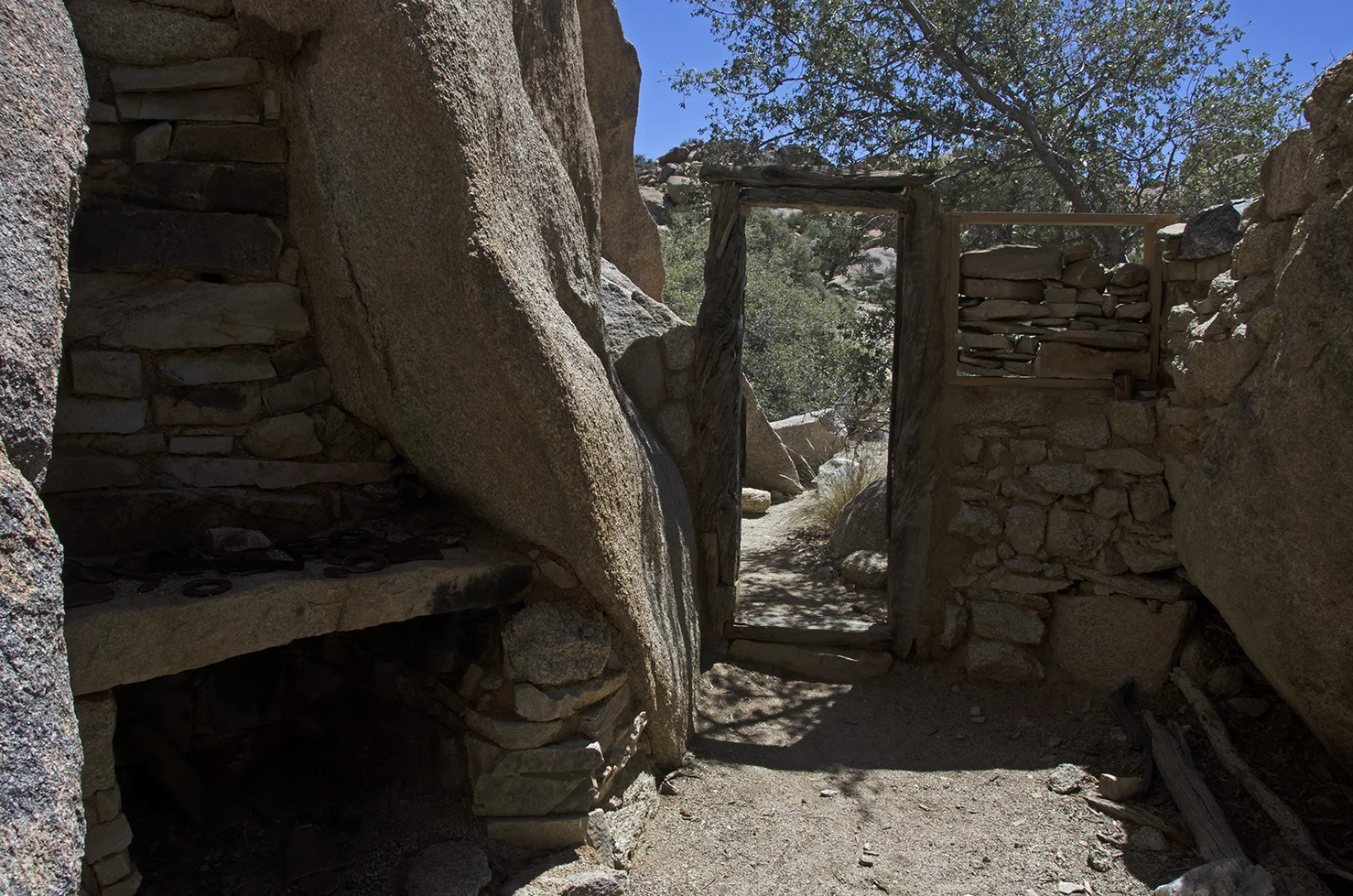
Just up ahead, you can make out the wood frame doorway that leads into one of the coolest spots in J Tree, a rock shelter cabin created from a narrow crevice in a jumble of massive granite boulders.
This 'cabin in the rocks' perfectly embodies the creativity and ingenuity of the early day prospectors and explorers in J Tree. The lure of gold brought people out here and someone made quite the intricate home to live in. It measures roughly 10 feet wide by 30 feet deep, with a little 'underroom' storage area way in the back. Rocks and cement create several walls and seal up several openings between the boulders. Flattened tin cans make up a portion of the roof, which is supported by branches obviously taken from the surrounding area when the place was built. The front wall has a woodframe doorway and window space. At one time, the front section of the cabin had a roof made from Pinyon pine branches and logs, but it has long since crumbled away. A masonry and iron stove is built into the northern end of the cabin and several shelves are on the walls. Bits and pieces of things have been placed on the shelves, a few pans hang on a 'mantle' above the stove. Perhaps the most amazing thing to me, is the six-pane glass window set into the masonry wall. All six panes still intact, which makes me happy each time I visit. Note: I just learned that a recent restoration project took place at the cabin. The Park Service, in collaboration with Cornerstones Community Partnerships, worked together to replace a couple of the panes of glass at the shelter. That was a nice thing to do.
The cabin and its artifacts are solid evidence that miners lived here for an extended period of time.


The roof made from flattened tin cans.
The view from the outside of the cabin. This place was well made. I think it would have been fun to be living inside during a thunderstorm.
Located nearby, this small contraption could have been an oven, or maybe a furnace of some kind, as there are reports of a blacksmith shop being in this vicinity.
Home sweet home. This spot is very picturesque. The group of boulders that the cabin is built into is known by the rock climbers as 'Fraggle Rock." Don't ask me why.
After poking around the area for a bit, it was time to head back. We took a slight detour to peek over the ridge down towards Split Rock. If you have sharp eyes, you can actually see it in the photo above. There is a trail from Split Rock that leads up to the Eagle Cliff, but after hiking it once, I definitely recommend taking the route from the Desert Queen Mine. Off in the distance, in the upper left portion of this image and along the base of the mountains, the white rocks mark the sites of Belle campground and White Tank campground. Past them in the distance lies Pinto Basin.
There's the backside of the Golden Claw, aka Power Shopping Boulder. Still a ways left to hike on the way back.
Lots of color on this small, rocky plateau.
I take a lot of pictures of dead trees, in fact, I have a folder full of them on my hard drive. This one turned out pretty good. The golden portions of the bark really makes this one stand out from all the others.
And to finish off this trip report, one last picture of the golden bark dead tree. With moon.
If you have the chance to visit the Eagle Cliff Mine and surrounding areas, figure on spending a good half day at least for the trek. And please, leave things as you find them so others can enjoy the site as well.