
Desert Queen Mine
/Trek Date: April 27, 2015
It was a beautiful morning for a hike in J Tree and the destination was the Desert Queen Mine. Even though most of the machinery, artifacts and buildings that were part of the mining operations are long gone, the lure of an old gold mine is still strong. Be sure to check out Murbachi's Desert Queen Mine page for some awesome 3D images, in several different formats. Click HERE to jump over THERE.
Most of the trail to the Desert Queen Mine follows the old mining road. From the parking area at the Pine City backcountry board, it only takes a few minutes to reach a viewpoint on the edge of a cliff that overlooks most of the Desert Queen Mine workings. There's an old winch still sitting at this spot, that was once used to transport ore across the canyon.
The view from up here is great. Look at all the mine workings. The wash immediately below this overlook is called "Gold Dust Gulch," which seems fitting enough. If you follow it downstream to the east, you'll eventually reach John's Camp and on the way you'll see this interesting sight. But that's from a hike on different day. Click HERE to read about where this old car is and the neat Boulder Cabin nearby.
Heading back south from the overlook, there's another relic from the days of J Tree gold, one of two old cyanide tanks that are still mostly intact, albeit full of bullet holes. Cyanide was used to extract gold from low-grade ore that had been reduced to a slushy slurry. It was a nasty business and could prove deadly.
From this point, there are a couple ways to get down to Gold Dust Gulch; the zig-zag 'trail' that leads almost directly down into the wash, or the old mine road that was once used by the miners. These days, my choice is the old mine road, for two reasons. There's neat stuff to see along the way, and it's a lot safer.
One of my favorite spots along this hike are the stone ruins of what was probably a home/bunkhouse/office type of building. The stone foundations show that there were perhaps as many as five rooms in this structure. The ruins are right on the old road at the point where it starts heading down towards the wash.
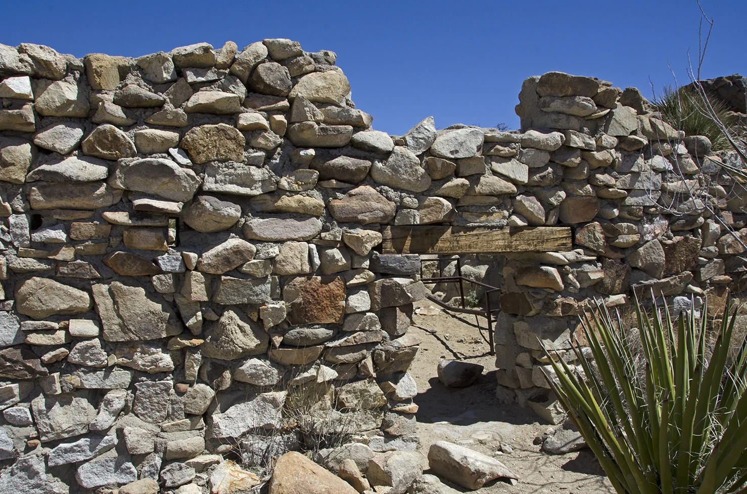
There are two small openings in the front wall of the cabin, which I'm pretty sure were for protection, as they look like rifle slots to me. Perhaps gold ore was stored in the building and these opening were used to take care of any varmints trying to sneak up and rob the place.
It's a rocky road on the way to the mines. Murbachi, the prolific 3D photographer, theorizes that the roads were probably filled in with gravel or cobbles back when they were in use. Which makes sense, as to travel along these roads today would certainly endanger any wagon or vehicle to breaking wheels, spokes or axels.
This nice view opens up once the road reaches the west ridge above the wash. That's a big pile of tailings and a great shot of one of the many grates. If you're interested in finding mines to poke into and explore, most of the mines in J Tree will disappoint in that regards. The Park Service has either grated, caved in, closed off or otherwise made entry into the great majority impossible. Which to me is sad, but probably necessary.
This huge boulder is just above the bottom of the wash and below the road that leads up to the mine workings. That dark hole underneath? Yes, it's a mine entrance. We'll arrive there soon.
Still up on the west ridge, with a little closer-up view of some of the workings of the Desert Queen Mine. There are a bunch of tunnels, shafts and adits in this area.
Nearing the bottom of the wash, a nice look at some climbing rocks straight ahead. Can you spot the Gold Nuggets, the Tailings and Poodle Rock?
Standing in the middle of Gold Dust Gulch. The upper left view is taken looking south, the upper right view taken looking north. Either way, there are places to explore. But as this hike was focusing on the Desert Queen Mine, Murbachi and I headed north to see what we could find.
I don't think I would have wanted to work in this mine.
Reaching my arm in around the edge of the grate, I got the picture on the upper right just as several bats flew out of the tunnel. I hate bats. Another great reason not to explore old mines.
During a detailed mine survey taken in 1976, the Desert Queen was recorded as having "four large vertical shafts, five inclined shafts, and ten adits, five of which had started caving." Hiking around the area, I think they may have missed a couple. This is the main tailing pile and it is about sixty-five feet tall. That's a lot of rock.
A couple pieces of the scattered desert gold that sit at the base of the giant tailing pile.
While up on top of the ridge at the beginning of this trek, I had spotted the other cyanide tank and miscellaneous mining debris a little farther north of where these two photos were taken. I had never hiked past this spot on previous trips, and since the day was young, I decided to see what I could find around the bend.


Another tunnel leading into solid rock and some bits and pieces of heavy machinery. Up on a ledge, the other cyanide tank. There are also a couple of cement foundations and some low rock retaining walls. Definitely worth the hike around the bend to check out.
Hiking back south in the wash to access the road leading up to the main workings, we passed several very large boulders. This one has some old initials etched into it, apparently by someone with the initials, "I.R." and then a name I couldn't make out. The date stands out plain, 1908. Was this inscribed by one of the early day miners?
The rocky road leading up to the main workings of the Desert Queen Mine. There are several small adits along the road; some are caved in, some go into the sold rock only a few feet. Whatever prompted the exploration in these small tunnels apparently didn't pan out.
This view is looking west across Gold Dust Gulch Gulch. The cyanide tank and winch are barely visible if you look close enough.
An air compressor and reservoir mounted on large wooden beams rests alongside the road, very near the top of the large tailings pile. "Chicago Pnuematic Tool Co." is embossed on one side of the compressor. This must have seen a lot of work during the mines operating years.
Looking down from the top of the main tailings pile. It's quite a slippery slope. That's a lot of rock and debris. I wonder where it all came from....
Possibly from this inclined shaft that is up behind the tailings pile.
I'm not sure, but I think this may have been one of the main workings of the Desert Queen Mine. This tunnel has been gated for safety. A couple of the mine cart rails still lead into its depths.
Details about the discover and history of the Desert Queen are sketchy, to say the least. There are several stories/legends about who discovered the claim and how it changed hands over the years. Many of the famous names of J Tree's past are linked with the DQ: the McHaney's and Bill Keys among them. Claim jumping, a knife attack, shooting, legal action and murder were all involved. When gold is in play, the stakes are high. By all accounts, the mine began operation in 1895 and had some good runs, some off years, changes of ownership and a lot of work done on improving the mines. At one time there were three redwood cabins used as living quarters at the mine, which Keys tore down after he acquired title to the claims in 1917. He later rebuilt one at his ranch which was used as the family kitchen. The final reported production took place in 1941, but the mine was still worked intermittently from 1948 to 1961. The U.S. Bureau of Mines gives a total production from the DQ of 3,845 ounces of gold. The actual production could have been quite higher, but we will never know.
Continuing up the road, there are at least six more mines either digging into the hill or plunging straight down into it; I guess it's a good thing they are grated.
Some of these vertical shafts have strange creatures living at the bottom, that have never seen the light of day....
This last grated shaft in the Desert Queen vicinity is atop the rocky hill that most of the mines explored. It's above and almost due east of what I think was the main tunnel for the DQ. I wonder if this shaft was dug to connect with that tunnel, maybe following another vein or to help ventilate the other workings. It goes straight down, a long way. I've seen people walk out onto these grates, I would definitely advise against that.
This large, split boulder is located near the last shaft. It quietly asked me to take its picture and publish it for the entire world to see, so I obliged. It's known as the "Power Shopping" boulder in the rock climbing world, but I'm going to call it the Golden Claw.
These little guys were having their spring fling. They were quite numerous along the trail. They are know to the botanical world as "Dudley saxosa," or "Panamint live-forever." A true desert perrenial succulent. This is the first time I can remember seeing them in bloom.
On the hike back to the parking area, Murbachi talked me into following a different fork of the road after we had crossed Gold Dust Gulch and started climbing up the trail. I had never explored this direction before, but we knew that it would loop back towards the parking area. After a bit of walking, several nice little plateaus opened up and off the road a bit I spotted something that was obviously created by man, it looked like a shelter of some kind.
It wasn't very large. Maybe at one time it was bigger, enough to provide shelter for someone staying in the area. Or perhaps it was for storage. A bit farther up the hill a suspicious looking hole beckoned to me; perhaps a cave?
Nope. No cave, but I did find some initials etched into the rock. They appear to be "I.C.R." Someone had spent considerable time at this spot carving their initials into the rock. Maybe done by the same person who etched the huge boulder back in Gold Dust Gulch.
Further exploration revealed several flat areas with rock boundaries, which were probably tent cabin sites. I'm pretty sure this area was once home to some of the men who worked the mine.
There was a good amount of desert gold scattered about, giving evidence that people once camped here.
A glass stopper for a bottle.
This is definitely an interesting spot, and it's not very far from the parking area at the Pine City backcountry board. I will definitely be returning here at some point, to give the area a more thorough exploration. You never know what you'll find in J Tree, which is one of the great things about visiting and just wandering around in the park.
Here's the tracks from this hike.