
Rt 66 - Two Guns, AZ
/Two Guns, Arizona was one of my favorite stops during the epic “Hitting the Trail to Texas” road trip. In fact, I visited it twice as I spent two days in the area driving thither and yon. I mean, the name itself demands a visit. The place has an amazing history, dating back to the mid-1800s. Click HERE for an in depth look at just what happened in Two Guns over the years (the Apache Death Cave, the murder of Earle Cundiff by Henry “Two Gun” Miller, the sale of human skulls, gila monster attacks, robbery, man-eating mountain lions and tourism).
During Two Guns blaze of glory, it was a favorite stopping point for people traveling Route 66. Over the years it offered a gas station, lodging, a café and Indian Trading Post. Along the canyon rim, a long stone structure was built. The front housed a small store and living quarters, while along the entire rear of the structure were wild animal cages and pens built of brick, stone, mortar and chicken wire. This was the “Lion Farm” and zoo, and was referred to as “Fort Two Guns.” There are a number of additional stone buildings around the property, in various stages of disrepair. They housed the restaurant and gift shops that intrigued tourists over the years.
What originally attracted me to Two Guns and put it on the list of must see places, was an image I found while researching for my trip. It was of an old stone ruin, with the words “Mountain Lions” painted across the front. I knew I had to check the place out, it sounded like my kind of (ghost) town.
I explored Two Guns in Two Stages. Stage one was the more modern portion of the location and included the abandoned gas station, wood frame building, water towers and the remains of the KOA Kampground. Stage two included all the old stone building ruins which date back to the early 1900s. Each area had its own unique appeal and I could easily have spent several more hours wandering about. I'm sure there are some spots I missed; hopefully I'll be able to return before they are further damaged or disappear completely.
This abandoned gas station is one of the first things I saw when I exited I-40. Even though I know I'm probably the millionth person to stop and look around places like this, there's some kind of fascination that draws me to them.
A wood frame store building sits opposite the gas station. My guess is that it once housed a typical Route 66 souvenir stand or general store.
Welcome to 2 Guns!
Just past the welcome to 2 Guns sign, this gravel road leads up to the main campground area. The two towers on the left most likely held water and had some very colorful designs painted on them.
I certainly wish "artists" would confine their desecration of historic spots to places that are not visible. Like the inside of their own homes perhaps. It really is a shame some people feel the need to graffiti.
This was the main camp building, the place you'd go to register, pay your camping fees, maybe buy some snacks and a drink. It was also the place for hot showers, as the remains of some large, tiled rooms inside attest. Many of the inner walls have been either damaged or weathered away down to the studs And of course, anything still remaining has been made less attractive by ne'er do wells.
An old bench behind the KAMP building.
An old road leading off to who-knows-where. Probably another lonely outpost.
The pools and bathhouse.
An old stretch of Route 66 leading to Two Guns.
The old, stone building ruins are located to the west of the modern section of Two Guns. They're accessible via a couple dirt roads and an old bridge that used to be the main route over Canyon Diablo. At one time not too distant, access to the stone ruins was closed with barbed wire fences, no trespassing signs and even a caretaker on the property. Luckily for me, the dirt roads were open, there was no caretaker and I didn't see any keep out signs. So I headed down the dirt road to see what I could find.
As you can see from the Google Earth image above, there are a lot of stone ruins and things to see on both sides of Canyon Diablo....I could have spent an entire day here. As it was, I spent a portion of two days at Two Guns and can see myself returning again sometime in the future. Arizona certainly has a lot of interesting places to visit.
These two stone ruins sit near the sharp bend of Canyon Diablo, near the big red 1 on the Google map above.
This image was taken looking down into a corner of Diablo Canyon. Underneath the remains of a wooden walkway which has fallen into the canyon, is the entrance to the "Apache Death Cave." The wooden ramps and ladders that once led down to the cave were either so rickety, out of place or dangerous-looking that this is as close as I got to the cave. It would have been interesting to climb down and try to explore the cave, but I'll leave that to the younger road travelers.
One last look at some of the ruins located at the bend, this place certainly had a spectacular view. I wonder what it was used for, maybe a ticket booth during the heyday, when people would pay to visit the "Apache Death Cave?"
Here's the building that enticed me to visit Two Guns. I mean, who could look at this old stone ruin with "Mountain Lions" painted across the top and not want to visit it? This ruin is located near the big red 2 on the Google Map above. As you can see from that image, there are a lot of ruins located in this area and I think this spot was perhaps the main attraction. This area sits on the north side of Canyon Diablo and this building appears to have been the entrance to the "zoo." Behind it are located a number of cages and pens which held the wild animals.
The backside of the zoo. It was quite a long structure.
Some close-ups of the various pens and cages. I'm not sure that I would have wanted to be up close and personal with a mountain lion, with only some chicken wire between us. But maybe the lion cages were a bit more secure....
This is a view of the old bridge that I would soon be crossing to get to the remainder of the ruins. It appeared safe enough, and wasn't blocked or closed in any way, so I drove across to get to section 3 of the area shown on the Google Map.
This large stone ruin is located on the edge of Diablo Canyon, right near the south end of the bridge. This was a large building, with several rooms and some big windows. Maybe it was a home or a store, or some kind of combination business and residence. It's an impressive ruin. One source states it at one time housed Cundiff's General Store.
A few different views of the large stone ruin. It's always interesting to me how when someone didn't want a window or door any longer, they would just fill it in with building material, as shown in the picture above, right.
Getting back in Old Blue, I headed a little farther west along the dirt road to section 3 from the Google map. There is an amazing group of stone ruins at that location.
This is one of the ruins that leaves no doubt as to what it was used for. Can you guess what it was? Click on the small image to the right of this text for a pretty good clue. --->
The next ruin I looked at was very intriguing. It was rounded on one end and had two levels, the top level reached by a staircase that wound around on the outside. Was it some kind of storehouse? Business? Lookout tower?
The view from the upper floor of the mysterious round end building.
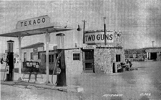
Aha, discovering this old post card reveals that the mysterious round building was once used as a Texaco station.
I saved the largest ruin for last. This long row of stone building remains is amazing. Perhaps this structure was the main trading post/restaurant/residence/motel section of Two Guns during its prime. And then again, maybe not. This old postcard below gives a glimpse of what it looked like back in the 1930s.
This appears to have been the main portion of the structure. It's a large building with several rooms. Smaller structures extend from each side of this main building.
The amount of stonework in these ruins is astonishing. I wish I could have seen them when they were complete and in business.
A few images taken from the backside of the ruins. It appears that there were a number of smaller, individual rooms. Maybe they were set up for travelers to spend the night.
Much as I would have liked to stay and more fully explore the area, I was on a roadtrip and Texas was calling. I had spent portions of two days at Two Guns and can definitely see myself visiting again the next time I'm in the area. Heading out back across the bridge, I stopped at the abandoned gas station one last time before getting back on I-40. Two Guns needed two munzees.