
Pinyon Well
/Trek Date: February 17, 2014
If you like to hike in remote, lightly used yet historic spots in Joshua Tree National Park, Pinyon Well canyon is the destination. Water, mining, milling and freighting have all created history in this canyon, as well as the Native Americans who once spent time in the area. Some of that history is plain to see. But some will take a bit of searching (and luck) to find, and that's part of the fun.

The trailhead to historic Pinyon Well Canyon.
The trailhead for Pinyon Well (and many points beyond, but those are posts for another day), is located at stop #15 on the Geology Tour Road - Pinto Well Junction. The wash heads southwest into the Little San Bernardino Mountains and believe it or not, was at one time a freighting road known as Pushawalla Canyon Freight Road. It was one of the main routes wagons would take from Indio to get to Pleasant Valley and the mines of that area, notably the El Dorado Mine.
After getting my gear together and taking a good drink of water, I started out into the wash. At times I'd slog though the sand (which takes a lot more energy), but when the canyon would widen and the wash would meander, I'd just head straight towards my next landmark.
Placed to make people wonder why.
I wasn't hiking for very long when I came across this iron eyebolt embedded into a huge granite rock. A little farther along was an iron pipe driven well into the desert floor. Discovering little things like this is one of my favorite things about hiking in J Tree, and then trying to figure out what they were there for.
Shortly after passing by the Pipe in the Ground, I spotted the most distinct game trail that I've ever seen in the park. I'm fairly certain it's a trail used by big horn sheep as they move from the Pleasant Valley area up to the rocky mountains farther up the canyon. Try as I did, I didn't see any big horns on this trip. I did see some lizards, beetles, a blue bird and others. I heard more birds on this hike than I usually do, which I am pretty sure has to do with the available water in the canyon.
I feel I am not the first to hike Pinyon Well Canyon....
I came to the first fork in the trail at about 1/4 mile, when a smaller wash came in from the south. While it looked interesting, I chose the right fork as I had done my research. Even though I'd never been up this canyon, I pretty much had my path memorized (and honestly, it's a very easy trail to follow). If you've read many of my posts, you've probably heard me mention Google Earth at least once. It's a great tool for planning out a route.
The weather was practically perfect, mostly clear blue skies and temps in the 70s. The only distraction the entire trip? Flies. Every now and then I'd be attacked by a fly with a taste for human flesh. I tried to keep up my pace as best I could, because when I would stop they would feast.
I knew I was getting close when I started seeing desert gold....
And I was right. At around the 2/3-mile mark I spotted a tailing pile on the left side of the trail. I had found one of the Pinyon Wells (The first? I'm not sure. I found two other sites that might also have been the original Pinyon Well. Maybe this one was the result of a miner who struck water?) In any case, the original Pinyon Well started off as a spring, where folks could obtain water by digging in the ground. While men searched for gold, water in the desert was just as important. So a well was sunk into what appears like solid granite at this site, a pump installed and a small camp was born.
Pinyon Well
See the water pipe on the right?
A previous visitor. Or what's left.
Heading past the small outcropping of rocks that holds Pinyon Well, I turned the corner and got my first look at the clearing which held the main focus of my destination. The site of the Pinyon Well settlement.
First view of Pinyon Well settlement area
So there was a steady supply of water, along a major road and near a good number of mines. It's logical that a camp would spring up near the water. One of the main attractions of the camp during its heyday was the steam-powered two-stamp mill erected in the very early 1890s. Known as the New Eldorado Mill, it was owned by Tingman and Holland who operated mines in the Pinyon mining district. But they would also crush ore for other mines in the area, in fact, Jim McHaney hauled ore here from the Desert Queen Mine.
A man by the name of George Wharton James visited Pinyon Well camp and in 1907 described it: "There are a few cabins and a stamp mill situated in a cozy nook in the mountains, and - pleasing fact - the homes of families, where the voices of women and children are heard." How cool is that.
Water was piped from the Pinyon well(s) some nine miles east to the Eldorado Mine for many years. Imagine the job of laying that pipeline. But as the years passed, the gold in the surrounding mountains began to give out and eventually the mill site was abandoned. Things deteriorated, scavengers scavaged, buildings collapsed. Nature began to reclaim the cozy nook. Thankfully, Bill Keys purchased the remains of the mill from the New Eldorado Company, dismantled it and hauled it to its present location, where it became the Wall Street Mill. He put the thing back together and ran the mill from 1932 to 1942, processing ore for local mines. It's now on the National Register of Historic Places.
The first artifact I examined at the site was an old metal water trough. It was probably fed by a spring up the small canyon behind the stone ruins. From there I headed up to check out the stone ruins. Was it a stone building, or stone walls with a wood frame atop? Maybe part stone, part tent or just a large tent site with the stone walls as additional protection from the elements. It's a fairly large area, which makes me wonder exactly what kind of building it was.
A large stone ruin


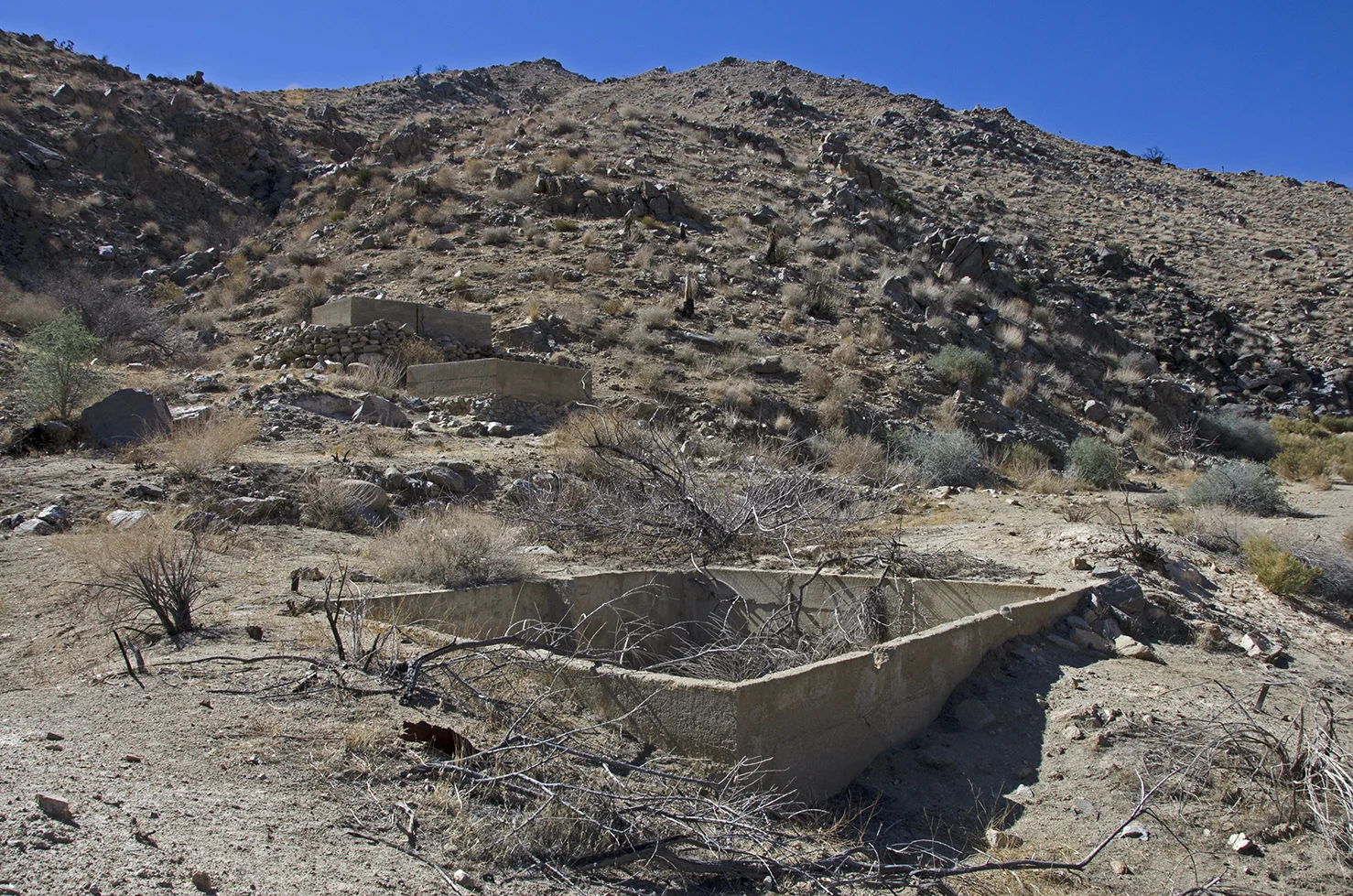
The cement water tanks
The three concrete water tanks are the most obvious reminder that Pinyon Well used to be quite the spot. They were probably used as water reservoirs to supply the stamp mill. I couldn't find any indication of where the stamp mill once stood, but my guess is fairly close to the lowest water reservoir.
Gulch to another well.
Above the water reservoirs is this small gulch that leads back to what I think is another of the Pinyon Wells. I couldn't get very close to what appeared to be a well, as it was a bit steep and vegetation almost completely covered the opening. I'm going to call this Pinyon Well #2.


Pinyon Well #3
Maybe another 50 yards or so up the canyon, the wash got kind of crowded with vegetation. I heard birds. Lots of birds. Again on the left side of the trail, at the base of the rocks, the plants got even thicker. As I got closer, I heard bees. Lots of bees. I don't like bees. Bees don't like me. So this is as close as I was going to get for a picture.
Round trip from the trailhead to Pinyon Wells is a little under two miles, but those two miles are really packed with things to see and places to explore. My next trip will definitely include investigating the side canyon up behind the stone ruins. I think there may be a spring up there that flows, oddly enough, in the spring. I'll be back to see what I can find.

33.895825° -116.094935°