
Mastodons in Joshua Tree National Park
/Trek Date: November 28, 2014
Yup, it's true. There are Mastodons in Joshua Tree National Park. Several of them, in fact, or at least their remains. There is the Mastodon Mine, the Mastodon Mill and Mastodon Peak. Did actual Mastodons ever live and breathe in this area? Probably. I was going to see if I could find some.
The Mastodon Peak Trail loop recently reopened; it had been closed for some time due to dangerous chemicals which had run off from mines during last year's heavy rainstorms. I was glad to see it open again, as I had been wanting to climb the peak and visit the mine for quite some time.
The trailhead for the Mastodon Peak loop is located at the parking area for Cottonwood Spring. This area has a rich history, dating back to when Native Americans lived in this region. It was once one of the only reliable water sources for miles in any direction. During the mining years from 1870 to the early 1900s, Cottonwood Spring was a popular stopover for freight haulers, prospectors and other desert travelers passing through. The miners are responsible for planting the cottonwood trees and fan palms, virtually all that remains from their time in the sun.
I arrived at the parking area around 10:00 am and the lot was already full; it was Thanksgiving weekend. I decided to hike the loop counterclockwise, just because. After gathering my gear and enough water for the 2.6-mile loop (more on that later), I hit the trail and was pleasantly surprised that I didn't see more than a dozen people during the four hours or so that I was hiking.
The trail starts at the top of the parking area and heads down towards the clumps of trees in Cottonwood wash. The path has a steel cable fence on each side, as the NPS doesn't want folks wandering into the wash along here. Signs point out that there could still be some dangerous chemicals in the sand, washed down from the mines which used them in the processing of ore.
A large granite rock sits about fifteen feet south of the trail shortly after crossing the wash. It has two very deep mortars ground into it. It's likely that there is other evidence of Native Americans in the area, but that is something to save for another trip. I was hunting Mastodons.
It wasn't too long before I was at a fork in the trail. To the left was the loop for Mastodon Peak, to the right would lead me to Lost Palms Oasis. I could hear the mastodon trumpeting; I chose the left fork.
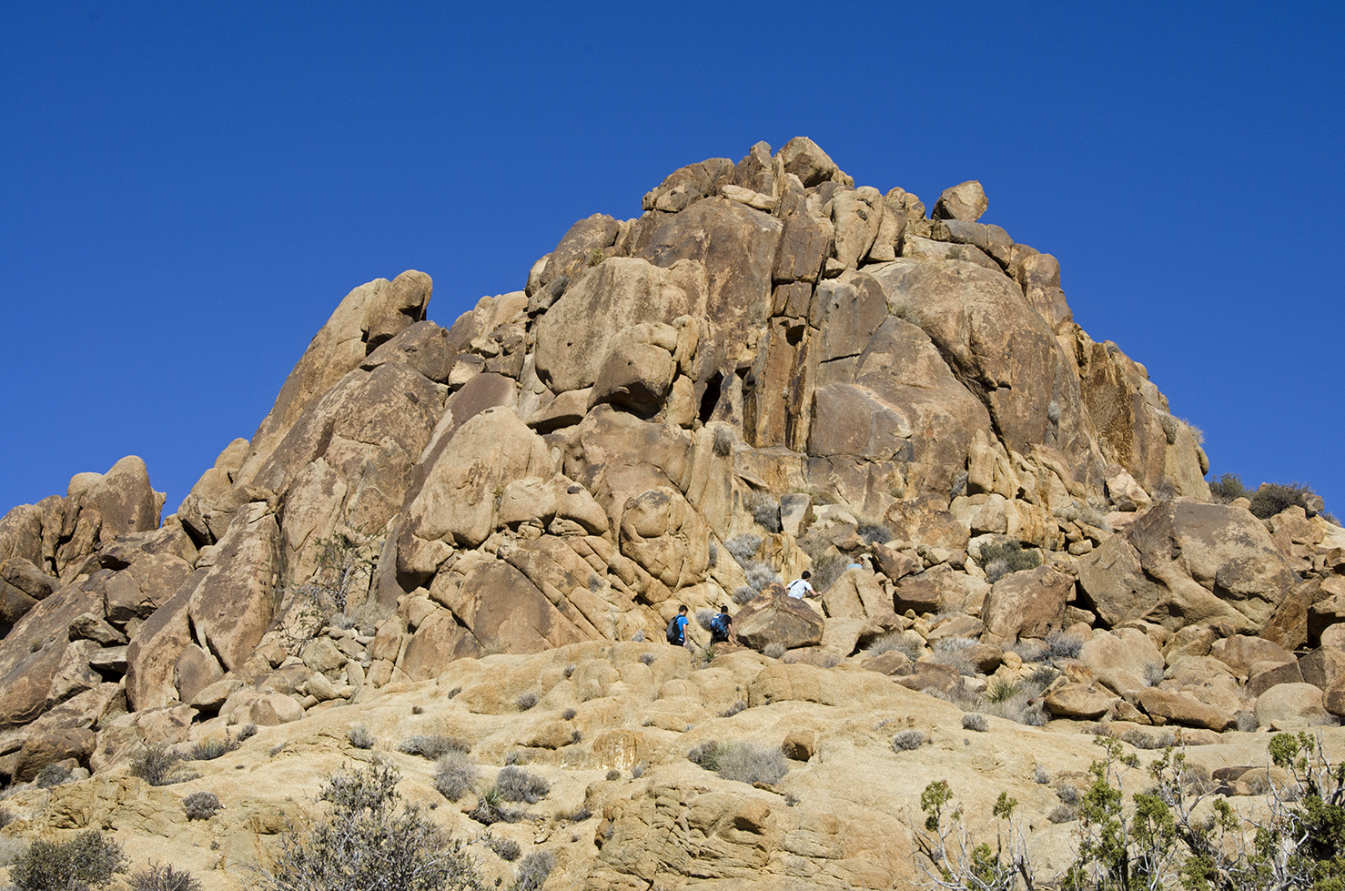
The trail became a bit steeper, but was easy to follow. Portions of the path had steps placed to aid hikers on their climb. Can you spot the two people in the photo above?
The Mastodon slumbers.
Nearing what appeared to be the top of the trail (Hiking Rule #16: There is always another rise or climb beyond what you can see ahead of you), I paused to take a look back along the trail. It was quite a view.
Wouldn't it be awesome to have witnessed this giant boulder split in half? What was the final straw that made it crack?
And there it was, a Mastodon in Joshua Tree National Park. Now I must admit, I look at a lot of rocks when I'm hiking out at J Tree. And many, many times the ancient spirit hidden inside the rock is plainly visible to me. But I looked at this peak from so many different angles and viewpoints and couldn't for the life of me see the Mastodon. I could only conclude that the miners who named this peak "may" have been a little tipsy, either from the altitude or maybe from imbibing strong libations around the camp fire. Maybe I could find a tusk up on top. The trail kind of peters out as it goes around the right side and it's basically a scramble to summit this peak. I commenced scrambling.
After defying gravity and risking life, limb and Nikon, I made it to the top. And it was definitely worth the climb. It's the highest peak in the area and offers a spectacular 360° view for miles and miles. Off to the south is the Salton Sea and beyond it a couple more mountain ranges.
And looking out over the other side, that's Eagle Mountain to the northeast. Both panoramas show what looks to be a lot of empty wasteland, but there's a surprising amount of life and history throughout the desert. It just takes some searching to find it sometimes.
A view from the top, during which I managed not to be blown off the peak. After enjoying the view for a bit, it was time to precariously make my way back down the mountain. Hiking Rule # 77: It's always easier climbing up things than it is climbing down things.
Arriving safely back down onto the main trail, I resumed my journey and was quickly rewarded with another Mastodon sighting, this time it was the remains of the Mastodon Mine.
The Mastodon Mine operated during the 1930s. The claim was owned by George W. Hulsey of Indio, and encompassed about 25 acres of land. There were two shafts, a mine office and a ball mill to crush the ore. One of the shafts was an incline shaft that reached a depth of 75-feet, the other was about 20-feet deep. The Hulsey family actually did some work on this claim up until 1971 when the property was acquired by the park.
The mine office building which once stood above the main shaft has long since collapsed on itself. Nothing but a pile of wood, timbers and corrugated metal remain are left. Nice places for snakes, though.
The main shaft has been grated for safety and is located right on the trail.
A one-chute ore bin and the remains of a crushing operation are on the opposite side of the trail as the grated shaft. I wasn't able to pinpoint the location of the second shaft reportedly on this property.
After poking around the scavenged bones of the Mastodon, it was time to resume my journey. Just a short distance farther along the trail is what appears to have been a stone-walled enclosure of some kind. Was it a foundation wall for a building? A holding area for supplies?
After leaving the Mastodon Mine, the trail appears to be the remains of an old road that led to the mine. It looks like a lot of work went into building this road.
This large wash joined the wash the old road was following and that big green tree looked interesting so I decided to head over there to see what I could find.
There are portions of a low stone wall near the big tree, perhaps there was a spring or well here at one time, maybe a camp. I didn't see any traces of habitation, other than the wall.
After exploring the canyon beyond the big tree for a short distance, I returned to the trail. It followed a good sized wash with interesting boulders on each side. Hiking Rule #49 states never assume that following a lot of footprints will lead you in the right direction. In the photo above, the two hikers are following the wash (and hundreds of footprints), to the left. That direction would probably take them where they wanted to go, if they were able to navigate the narrow canyon and steep dropoffs they would soon encounter. I know, because I walked that same way too, only be find further travel impossible for me. The actual trail departs from this wash on the right side, between two clumps of bushes, at about 2:00 o'clock on the picture above. Looking at the picture now, there are several large rocks crossing the wash towards the trail.
The trail snakes through this narrow rock pass as it joins yet another major wash. It appears that there was once a gate at this location. Possibly constructed by the owners of the Mastodon Mine to keep unwelcome visitors off the road to the mine.
The trail passes quite near the ruins of the Winona Mill at Cotton Spring. There are several old cement walls and foundations. But that's a story for a post of its own.
I continued down the wash which becomes part of the Cottonwood Nature Trail. This old cement water trough is nearly filled with sand, but at one time it would have been filled with water piped down from Cotton Spring. It appears that corrugated sheet metal was used for molds when the cement was poured to create this trough.
The Cottonwood Springs Nature Trail has informational signs along the way, it runs from the campground to the parking area at Cottonwood Springs. Above, I passed by yet another sand-filled water trough.
I'm guessing that this trail marker, when originally paced, was about four feet above ground level. The sand and gravel coming down from this wash has almost buried it completely.
Full circle, I had returned to Cottonwood Springs. This is a very interesting trail and a wonderful way to spend a few hours hiking in the Colorado desert (part of the Sonoran desert) portion of J Tree. You'll meet a lot of creosote bushes, some ocotillo, fan palms, cottonwood trees, mojave yuccas, juniper and something that surprised me, Eucalyptus trees. They must have been brought in by miners during the early 1900s.
The Mastondon Peak Loop is definitely a hike I recommend, I'm certainly glad the trail has been reopened. Check it out during the fall, winter or spring and take a lot of water with you. There are a number of places along the trail to sit and enjoy the day.
How I can turn a "2.6-mile" loop trail into a 4.25-mile jaunt in the park.
If you've enjoyed reading this post, please feel free to comment. A "Like" of the Cali49 Facebook page would also be appreciated. And everyone is welcome to use any of my photos for projects of their own. Credit back to this site would be nice, but is not required.