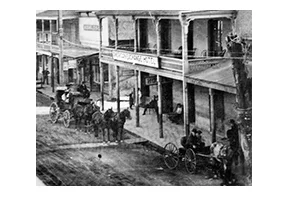
Shingle Springs, Cal
/
A cluster of cool, clear springs surrounded by oaks and sugar pines made this spot a natural stopping point for emigrants traveling along the Carson Emigrant Trail. One such traveler was David B. Scott, who left Monroe, Michigan in 1849 to cross the plains and come to California. He was so impressed with this area that when his party disbanded in Sutterville, he returned here with a group of men in 1850 and erected a shingle machine near the springs, from whence the town took its name.
Read More